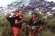
The Seven Sister States also called "Paradise Unexplored" is a name given to the contiguous states of Arunachal Pradesh, Assam, Meghalaya, Manipur, Mizoram, Nagaland and Tripura in northeastern India.There is great ethnic and religious diversity within the seven states; they also have similarities in political, social and economic contexts.
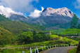
Arun+Anchal as the name suggests, this place is the Land of the Dawn-lit-Mountains, The sun touches the sky of Arunachal Pradesh first before the rest of the India. Located in the north-eastern part of India, its dense forests, snow clad peaks, towering mountains and roaring rivers are marvelous attractions for the tourists. Rafting, hiking and mountaineering, adventurous tourists will get all opportunities. Specially, Bomdila-Tawang area is an ideal place for trekking. As it rains for most of the year and winters being too cold, May and October is the best time for undertaking adventure activities. Also this Himalayan state has rich flora and fauna, with more than 550 rare species of orchids and hundreds of species of rare plants.
NAHARLAGUN
 |
Polo Park : Polo park is a little botanical garden located at the top of a ridge that overlooks the entire town of Naharlagun. One peculiar feature of this park that visitors should not forget to notice is the cane thicket, which looks a bit like a palm, with spines on its stems, but which is growing as a bush. Also, there is also a small zoo. The zoo is located18 kms from Naharlagun and near Banderdewa police check post. If someone wants to have hand made shawls, carpets, carved caskets & the beautiful cane & bamboo items , there is a Handicrafts Centre run by the Industries Department which offers quite a range of items. Also, Pachin River which provides a fine fishing spot passes by Naharlagun.
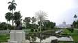
ITANAGAR
 |
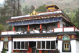
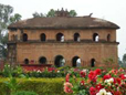
The Buddhist Temple: The capital of Arunachal Pradesh Itanagar has a new, beautiful, yellow-roofed shrine, the Buddhist Temple. It rises in a well-maintained ground behind a stupa bearing the portrait of a monk. At one side is a tree planted by His Holiness the Dalai Lama. The grounds of the temple afford a good view of Itanagar town.
 |
Ganga Sekhi Lake: A 6 km drive to the lake from Itanagar takes visitors on a rugged road through some superbly primeval jungles: bamboo, orchids massed on tall trees, tree-ferns are some of the vegetation which can be identified by the interested traveller. Stopping at the base of a hill, one has to cross a bamboo bridge floored with a bamboo mat spanning a culvert. This leads to a flight of steps cut into the red clay of the hill. At the top of the ridge one looks down at a serene, green forest lake which one can cross in a row boat. It’s an ideal beautiful picnic spot.
Assam is a land of myths and mystery. "The land of red rivers and blue hills," as it is described, has a unique landscape with sprawling tea gardens and unending stretches of paddy fields interspersed with groves of coconut, areca nuts, and banana trees. Besides that there are a number of national parks, that are host to rare species of flora and fauna. There are a number of tribes, each having their own story of lineage and origin.
Guwahati
 |
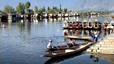
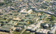
Situated on the bank of the mighty river Brahmaputra, Guwahati - said to be the legendary Pragjyotishpur or City of Eastern Light - is the gateway to north eastern India. The name is a combination of two words: Guwa meaning areca nut and Hat meaning market. Guwahati is the commercial nerve centre of the North-East. The places to visit Kamakhya Temple, Basistha Temple, Balaji Temple, Sukreswar Temple, Rudreswar Temple, Umananda Temple, Ugratara Temple, Shankardev Kalashetra, Accoland, Jyotichitrobon, etc. and shop for handicrafts and handloom items include the State Government's department store, Pragjyotika at Ambari as well as several private shops in Pan Bazar and Fancy Bazar, two of the main commercial markets.
Sivasagar
 |
Sivasagar was the capital of the mighty Ahoms, who ruled Assam for more than six hundred years, before the advent of the British. The town, which literally means 'the ocean of Lord Shiva', is strewn with the tell-tale ruins of a powerful empire. The most remarkable landmark of the town is the 200 year old Sivasagar tank. On its banks are three significant temples - Shivadol, Vishnudol and Devidol.
Tezpur
Situated on the banks of river Brahmaputra, this town replete with a raw natural beauty and fascinating archaeological ruins, is the headquarters of district Sonitpur. Undulating green valleys surrounded by the lofty hills and snow-capped peaks of the Himalayas, and lush tea gardens render Tezpur a tourist's delight. There are many spots which bear historical and mythological importance.
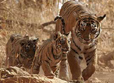
Manas
Sanctuary & Tiger Reserve Formerly known as North Kamrup, Manas, in Assam, was declared a sanctuary in 1928. In 1985 it was accorded the status of World Heritage Site. The park straddles two rivers, the Manas and its tributary the Hakua, along the Assam-Bhutan border. The protected area extends into the Bhutan foothills. Besides tiger this park is famous for its beautiful and rare flora and fauna.
Kaziranga
 |
Kaziranga National Park is one of the largest Protected Areas in India and one of the most significant conserved forest areas on the earth. From the time it was declared as a Proposed Reserve Forest for the Great Indian One-Horned Rhinoceros (Rhinoceros unicornis), it has become an exceptional model in conservation, also providing an ideal habitat for numerous other threatened species. Despite instances of poaching, this park has recorded a significant increase in the number of one horned rhinos . The entire park is divided into two ranges Kohora Range and Bagori range. There are a number of tourists lodges with excellent facilities , that are at par with other national and international standard. Beside Rhinos Kaziranga is home to many rare species of flora and fauna. One can have elephant safari and also jeep safari.
This state might not be in news for good reasons, but nestling within a lush green corner of North Eastern part of the country, is the amazingly beautiful little shangri-la called Manipur. Its literal meaning is jewelled land. There are ample scenic beauty that is going to lure the tourists.
Imphal
 |
This is the capital of Manipur which is bustling into a mini metropolis. It is well connected by road with Guwahati (Assam) through National Highway 39 and Silchar (Assam) through National Highway 53. There is also provision to go by air.
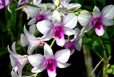
Khomghampat Orchidarium
Located at 7 kms away from Imphal on National Highway 39, is the Central Orchidarium, which covers 200 acres and houses over 120 rare varieties of orchids, which include almost a dozen endemic species. This place is all full of colours at most of the time, however one gets to see the best here during the peak blooming season that is between April to May.
Manipur Zoological Garden
6 km to the west of Imphal, at the foot of the pine growing hillocks at Iroisemba, on the Imphal-Kangchup Road are the zoological garden. The most important inhabitant of this park, is the graceful Brow Antlered Deer, one of the rarest species in the world.
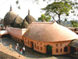
Bishnupur
27 kms from Imphal is Bishnupur, famous for the conical roofed shrine, dedicated to Lord Vishnu. Built in 1467, during the reign of King Kiyamba, the temple is interesting for its antiquity and Chinese design.
Moirang
45 kms away is Moirang, one of the principal centres of early Manipuri folk culture, with an ancient temple of the pre-Hindu deity Lord Thangjing. In May, men and women attired brilliantly sing and dance in honour of the Lord at the Moirang Lai Haraoba, a ritual dance festival held annually.
Ukhrul
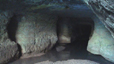
83 kms to the east of Imphal, this district headquarters of Manipur East, is the highest hill station of Manipur. A centre of the colourful warrior tribe Tangkhul Nagas, it is well developed, and renowned for a peculiar type of landlily - the Siroi, grown on the Siroi Hills. Siroi Hills and KhangKhui Lime Caves are interesting places for excursions.
Kaina
It is a hillock, about 920 m above sea level, and a sacred place of the Hindus. The sylvan surroundings, and the aura of serenity that envelopes it, add to the solemnity of the site. Kaina is 29 kms from Imphal.
Keibul Lam Jao National Park
 |
This tiny park, perched on the edges of the Loktak Lake, is home to the Sangai or Manipur brow-antlered deer (the endangered dancing deer). It has the unique distinction of being the only floating National Park in the world. Only 40 sq.km in area, the park was once a hunting reserve. It was declared a sanctuary in 1954 when a great number of the Sangai were getting seriously decimated. The deer, noted for their curving antlers, live on the floating vegetation on the Loktak Lake.
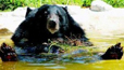
The state is a land locked territory of lovely hills with abounding sylvan beauty. Bounded on the north and east by Assam and Bangladesh on the south and the west. Its hilly terrain with varied elevation and heavy rainfall account for a rich variety of flora and fauna. The state is famous for its beautiful butterflies and exotic orchids. Hornbills, Cloded Leopards, Golden Cats, Golden Langurs are some of its unique wildlife.
Meghalaya is the homeland of three of India's ancient hill tribes eg, The Khasis, the Jaintias, and the Garos. The people here are strongly build and very hard working. Dance, Music and Sports reflect their way of life. Absence of Caste divisions and equality of sexes happen to be distinctive feature of their community life.
Shillong
 |
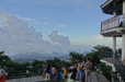
Shillong, located at a height of 1,496 mts above sea level, is the capital of Meghalaya. The city derives its name from the deity Shyllong or Lei Shyllong, which is worshipped at the Shillong Peak. Shillong is an exquisite hill station nestling on a plateau of the Khasi and Jaintia hills & Assam. Visit the secretariat, Raj bhawan ward, lake Bishop and Beadon Falls, The gold cup and of course the colorful Bazars.
Shillong Peak
An ideal picnic spot, it is just 10 kms from the city. Located at an altitude of 1965 m, it offers a panoramic view of the idyllic surroundings.
Cherrapunjee
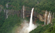
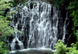
Situated in one of the heaviest rain-belts in the world, Cherrapunjee is 56 kms from Shillong, and perched at an altitude of 1300 m. This lovely town with its beautiful Nohsngithiang waterfalls, is also famous for its limestone caves and orange honey.
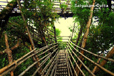
Mawlynnong
Mawlynnong/Mawlynnong Village located in the East Khasi Hills of Meghalaya, also referred as ‘God’s own garden’ has won the acclaim of being the cleanest village in Asia in 2003. The village known for its cleanliness is located around 90 kms from Shillong and is a community based eco-tourism initiative. The community has made collective effort to maintain the ambience of a clean village. The village offers picturesque natural beauty, a trek to the living root bridge at a neighbouring village Riwai. The village also offers a sight of natural balancing rock, a strange natural phenomenon of a boulder balancing on another rock.
Jowai
Jowai, headquarters of the Jaintia Hills district is, situated 64 kms from Shillong, on the Shillong-Silchar national highway.
Syndai
This village is dotted with a number of caves and caverns, used as hideouts during the wars between the Jaintia Kings and foreign intruders.
Tura
Tura, a town in the Garo Hills, boasts of a wonderful landscape of lofty hills, against a backdrop of low-lying plains, with the mighty river Brahmaputra, dramatically rushes through, towards Bangladesh.
Mizoram lies between the countries of Bangladesh and Myanmar. This state is mainly inhabited mainly by tribesmen who are mostly Christian at present. This state recently is the most literate state in India
Aizawl
Aizawl is the capital of Mizoram. It is located at an altitude of 4000 ft. above sea level. Aizawl is situated on a high ridge surrounded on the east by the deep green valley of river Tuirial and on the west, by river Tlawng, and on the north by beautiful high craggy hills of Durtlang. Aizawl is an ideal hill station adorned by picturesque scenery and peaceful surrounding with enjoyable weather.
Tamdil Lake
Tamdil Lake is located 85 km from Aizawl near saitual village. It is a beautiful natural lake in the midst of cool, green forest. It offers an ideal picnic spot and boating facilities for the tourists. People usually enjoy and pass their long hours in boating. Accommodation to stay is also available at the Tourist lodge, at Saitual village only 7 km away from the lake.
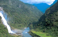
Vantawng Waterfalls
Vantawng water falls is located near an idyllic beautiful town of Thenzawl, 137 km from Aizawl. This waterfall is one of the largest waterfalls of Mizoram, fall from a height of 750 ft. This fall is surrounded by a lush green tropical forest filled with bamboo groves.
Champhai
 |
Champhai place is situated on Indo-Myanmar border, 192 km from Aizawl. It is a cool and healthy surrounded by blue hills. From here a tourist can view the fabulous hills of Myanmar hills. The town is a fast developing venue for Indo-Myanmar border trade for marketing all kinds of goods. The famous Rohdil lake inside Myanmar is only 22 km away from this town.
Nagaland is a hill state like many others in the North-Eastern region of India. The state is bounded by Myanmar in the east; Assam in the west; Arunachal Pradesh and a part of Assam in the north with Manipur in the south. It offers rich incomparable traditional and cultural heritage. The distinctive character and identity of each tribe in terms of tradition, custom, language and dresses is clearly discernible to a visitor. The respective tribal festivals are celebrated at regular interval all over the state.
DIMAPUR
 |
Dimapur is situated at an altitude of 195 metres above sea level. It is the Gateway of Nagaland. This fast developing town is also the commercial centre of the state which is connected with the main broad gauge railhead. Dimapur has the only Airport in Nagaland.
Chumukedima
It is situated just about 14 Km from Dimapur on National Highway 39. This place served as the first headquarters of the then Naga Hills District of Assam State during the time of British Rule in early 19th century. The Department of Tourism is constructing a Tourist Village on top of a hill.
Intangki Wildlife Sanctuary
The Sanctuary lies at a distance of 37 Km from Dimapur. The Sanctuary is under the preservation of the Forest Wildlife Department. This sanctuary is the habitat for various animals including some rare species of birds.
KOHIMA
State Capital and hill station is situated at an altitude of 1,444.12 meters above sea level. It is a beautiful town presenting wide panoramic views.
Kohima Village (Bara Basti)
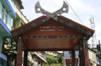
This is one of the biggest and most populous village in Asia. As you enter the village, there is a large traditional wooden gate with the scimitar of horns of buffalo head pointing towards the bravery and valour of the Angamis. It feels as its is greeting you. The Naga stones erected here and there in front of the houses are memorial symbols of the grand feasts arranged by their great ancestors.
Khonoma
Located 20 Km towards the west of Kohima, this village has its own traditions of valour and courage. History reveals that Khonoma provided protection to several villages in the good old days. The terraced fields which produce 20 types of paddy at different elevations present a beautiful view. The Khonoma gate tells you the story of the British infiltration into Naga Hills.
Dzukou Valley
Situated at an altitude of 2438.4 meters above sea-level, behind the Japfu Peak, it is 30 Km to the south of Kohima. The entire valley is overshadowed with a type of tough bamboo brush to make the place appear like a mown lawn.
Japfu Peak
Situated at an altitude of 3048 meters above sea-level, 15 Km south of Kohima, it is the second highest peak in Nagaland. It is ideally suited for trekking and scaling from November to March. From the peak, one can have a panoramic view of the hills below.
Tseminyu
Home of the Rengmas, Tseminyu is situated at an altitude of 1,421.95 meters above sea-level at a distance of 55 Km from Kohima. It is known for Ngada the popular festival which is celebrated in November, every year.
Peren
It is situated at an altitude of 1,445.36 meters above sea-level 84 Km from Dimapur. It is the homeland of the Zeliang and Kuki tribes. The place is famous for Zeliang dance in pairs.
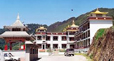
The tiny state of Sikkim is also called the Himalayan State. This beautiful state seems to be cradled by Bhutan on the east, Nepal on the west and Tibet on the north. Sikkim is situated amongst the highest peaks of the Eastern Himalayas, along the higher reaches of the Tista River Valley. An independent kingdom till 1975, Sikkim thereafter joined the Indian Territory to become the 22nd state of the Indian Union. This state is quite a popular tourist destination, both international as well as domestic.
Tsomgo Lake
Tsomgo lake is only 40 kms. from Gangtok town and is situated at an altitude of 12,210 ft.
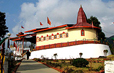
Rumtek Dharma Chakra Centre
This famous Buddhist Monastery is situated 24 Km away from capital city Gangtok. The seat of the 17th Gyalwa Karma, late His Holiness Rangjung Rigpae Dorjee, it is believed that the monastery, built in 1960 is a replica of the original Kagyurpa Monastery in Tsurphu, Tibet.
Shri Nalanda Institute for Higher Buddhist Studies
Initiated by the late 16th Karmapa, the institute is housed in the adjoining building of the Rumtek Monastery. The Jamyang Khang Primary School meant for 5 years of primary monastic studies is also located here.
Jawaharlal Nehru Botanical Garden
Very close by to Rumtek Monastery, and maintained by the parks and Gardens unit of the Forest Department of the Government of Sikkim, the Garden is an enchanting and soothing experience among the lush green vegetation, rare plants and trees and certain species of Himalayan flowers and Orchids.
Permanent Flower Show
White Hall, Close by the White Memorial Hall and just below the Palace Ridge park is the more recent Flower Show Hall. In recent years this show has become quite popular and famous as there are flower exhibitions throughout the year in accordance with the seasons and the flowers in bloom.
Enchey Monastery
An important seat of the Nyingma order, the Enchey Monastery meaning the Solitary temple, was originally built with the solace that no other construction would be allowed near it is built on the site blessed by Lama Druptob Karpo, a tantric master known for his flying powers. This 200-year-old Monastery has in its premises images of god, goddesses and other religious objects. Every year around January 'Chaam' or religious masked dance is performed with great fanfare for two days. it is situated adjoining the Sinolchu Tourist Lodge, 3 kms from Gangtok Town.
Hanuman Tok
It is approximately 5½ km. from Gangtok town. The town has a temple dedicated to God Hanuman.Besides offering prayers, one can enjoy the scenic beauty of Gangtok town and have a satisfying glimpse of Mt Kanchendzonga, which is snow clad. Number of people throng this religious site on Tuesdays and Hanuman Jayanti.
Tashi View Point
Built by the late King of Sikkim Sri Tashi Namgyal, it is situated 4 km from Gangtok town from where one can have a clear view of opposite hills, besides Mt. Kanchandzonga. This site offers a breathtaking panorama of the majestic Mt.Kanchandzonga and surrounding hills.
Ganesh Tok
It is a very small temple of Ganesh, a God worshipped by Hindus. It is on a hillock on Gangtok-Nathula Road. A Sikkim Government nursery is just nearby.
Saramsa Garden
About 14 kms from Gangtok is the Saramsa Garden, the home of Sikkim's most exotic orchids and other rare tropical and temperate plants. Established and maintained by the Department of Forest, it is an excellent recreation and picnic spot.
Water Garden
Water Garden at Martam Khola is on the 31-A National Highway some 16 kms. south of Gangtok. It is an ideal spot for picnic with a small swimming pool for children.
Sa-Ngor-Chotshog Centre
 |
It is a Tibetan refugee monastic institution established in 1961 by his Eminence Luding Khen Rimpoche, Head of Ngorpa, sub-sect of the Sakya Order, with the blessing of H.H. Sakya Trizin and H.H. the Dalai Lama. This is the only monastery of the Sakya Order of Tibetan Buddhism in Sikkim. It is located on a beautiful hill-top just 5 kms away from Gangtok Sikkim.
Tripura is a land of transition; a satisfying compromise between the old order and the new; a fusion of styles and cultures of the hills and plains. Previously princely state, and subsequently a Union Territory of Independent India, Tripura was elevated to the status of a state on January 21, 1972. Today, Tripura is largely a Bengali Community, inspite of the 19 Scheduled Tribes, that form a major chunk of the population. Hinduism, Islam, Buddhism and Christianity are the main religions followed in Tripura.
Agartala
 |
Capital of State, Palaces,Temples, Lakes Rudhakishorepur: Palace, Temples Rudranagar: Lake, Palace, Boating Forest.
Sipahijala
Reserve, Zoological & Botanical Garden, Lake Udaipur: Ancient capital, Temples Dumbur:Waterfalls, Lake, Boating.
Jambai
Hill range, Scenic beauty, Tribals, Land of eternal spring. |